Source: The Conversation (Au and NZ) – By Julie Jakoboski, Oceanographic Data Scientist, Moana Project’s Te Tiro Moana Team Lead, MetService — Te Ratonga Tirorangi
Moana project, CC BY-ND
The world’s oceans are buffering us from the worst climate impacts by taking up more than 90% of the excess heat generated by greenhouse gas emissions. This has warmed them by 0.88℃ (on average globally), according to the latest climate report released this week.
The warming of the ocean affects marine ecosystems, drives changes in ocean circulation and heat distribution, and strongly influences atmospheric weather systems. All these processes are critically important to the health of our planet.
Read more:
Ocean heat is at record levels, with major consequences
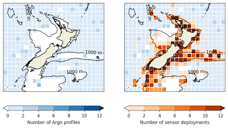
Scientists measure subsurface ocean temperature around the world, but there is a coastal gap in those measurements. This is where fishing, aquaculture, recreation and ocean managers need good data the most.
MetService’s Moana Project is changing that. We have joined forces with the commercial fishing sector to deploy sensors on vessels nationwide to gain insights into how ocean temperatures are changing near the coast.
John Radford/ZebraTech, CC BY-SA
Monitoring coastal changes
Ocean temperature measurements are critical for understanding and accurately predicting extreme events, including severe storms and unusually warm coastal waters, which have serious economic and societal impacts.
During the past few years, Aotearoa New Zealand has been plagued by extreme rainfall and persistent marine heatwaves. This has severely affected marine life, fisheries and aquaculture.
Increased ocean temperatures can exacerbate severe weather events like Cyclone Gabrielle, contributing to the conditions for intense rainfall and potential devastation.
To prepare for a changing climate and provide early alerts for extreme events, we need to monitor temperature changes below the ocean’s surface. These measurements are usually expensive, often requiring oceanographic research vessels to deploy instruments.
Pioneering international programmes like Argo (autonomous floats that move with the world’s ocean currents collecting measurements) provide unprecedented world coverage of deeper waters.
But they are not primarily designed to measure coastal and shelf seas. The lack of coastal observations is recognised in New Zealand and globally, and is a priority for the United Nations Decade of Ocean Science 2021-2030.
Moana project, CC BY-ND
Crowd-sourcing ocean observations
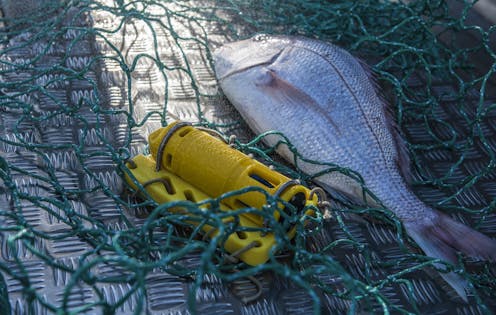
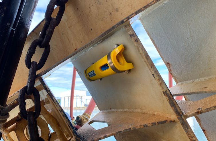
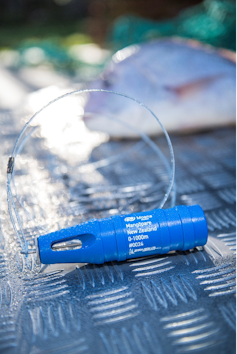
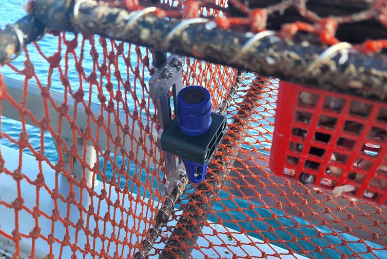
As part of the Moana Project, MetService and the commercial fishing industry partnered with Nelson-based company ZebraTech to develop the Mangōpare sensor, a small, lightweight, robust and accurate temperature sensor that attaches to commercial fishing gear.
Moana project, CC BY-ND
The sensor was distributed to volunteer inshore and deep-water fishing vessels and citizen scientists. Thanks to more than 200 skippers and crew, there are now 300 sensors on commercial fishing vessels, providing more than one million subsurface observations a month from across Aotearoa New Zealand.
The sensor attaches to any type of fishing gear and automatically collects ocean temperature and depth measurements through the water column. This information is automatically sent to the cloud, quality checked, returned to the fisher collecting it and incorporated into MetService ocean forecasts.
Vital temperature record to improve forecasts
Temperature observations are used to improve ocean forecasting models and verify the depth of marine heatwaves around Aotearoa New Zealand.
Similar to a weather station on land collecting real-time data that improves weather forecasts, sensor data helps improve three-dimensional predictions of ocean temperature, currents and sea level. These forecasts are used to prepare coastal communities for approaching storms, optimise fishing and alert aquaculture to extreme ocean temperatures.
Scientists use the sensor data to understand how ocean temperature affects our marine ecosystems. Recently, severe marine heatwaves have affected coastal and offshore areas leading to changes in fish distribution and impacts on sensitive species.
The sensor provides measurements exactly where fishing occurs, helping fishers make sense of changes in their catch.
William Maclardy, CC BY-SA
Temperature measurements are an invaluable record of subsurface ocean structure, allowing scientists to determine impacts of marine heatwaves, such as the bleaching of Fjordland sponges. Increased understanding is essential to a climate-resilient future for our oceans and marine species over the coming decades.
Partnering with technology innovators, the commercial fishing sector, citizen scientists and researchers from across New Zealand, this project breaks down traditional barriers.
This approach demonstrates how we can solve critical environmental issues and provide important insight into our changing oceans. The continuation of this system will lead the way toward informing a climate-resilient blue economy and understanding the coastal ocean, providing measurements that will only become more critical in the coming years.
![]()
Julie Jakoboski works for the Meteorological Service of New Zealand – Te Ratonga Tirorangi. The Moana Project is funded by New Zealand’s Ministry of Business, Innovation, and Employment – Hīkina Whakatutuki.
João Marcos Azevedo Correia de Souza works for the Meteorological Service of New Zealand – Te Ratonga Tirorangi. The Moana Project is funded by New Zealand’s Ministry of Business, Innovation, and Employment – Hīkina Whakatutuki.
Malene Felsing works for the Meteorological Service of New Zealand – Te Ratonga Tirorangi. The Moana Project is funded by New Zealand’s Ministry of Business, Innovation, and Employment – Hīkina Whakatutuki.
– ref. Fishing for data: commercial fishers help monitor rising temperatures in coastal seas – https://theconversation.com/fishing-for-data-commercial-fishers-help-monitor-rising-temperatures-in-coastal-seas-202115