Source: The Conversation (Au and NZ) – By Kimberley Reid, Postdoctoral Research Fellow in Atmospheric Sciences, Monash University
Headlines declaring a “Black Nor’easter” appeared this week as New South Wales and Queensland copped heavy rain – and residents have been warned to brace for more.
The Bureau of Meteorology is forecasting a 75% chance of Sydney receiving at least 50mm of rain, and a 25% chance of at least 100mm of rain on Friday (the average rainfall for the entire month of April in Sydney is 121.5mm).
Parts of Sydney were drenched in more than 100mm of rain overnight and the main dam that supplies the city’s drinking water is expected to spill in coming days. At least one man has died in Queensland floodwaters after torrential rain.
You might be wondering: what is a Black Nor’easter, what’s causing all this rain and does it have anything to do with climate change? I’m an atmospheric scientist who researches atmospheric rivers, extreme rainfall and climate change. Here’s what you need to know.
Read more:
Like rivers in the sky: the weather system bringing floods to Queensland will become more likely under climate change
A wavy atmosphere leads to wild weather
Nor’easter simply means the wind comes from the northeast and black refers to the thunderstorm clouds likely to darken the sky.
Pirate-esque poetry aside, this type of weather system is not that unusual for this time of year, and technically the weather system started in the south.
But to understand the bigger question of why the east coast is copping all this rain, you need to remember the atmosphere is a fluid.
That means the same laws of physics that apply to water in the ocean also apply to air in the atmosphere. Like the ocean, the atmosphere has waves that break.
The jet stream is a current of fast winds about 10km high that blows from west to east and steers high and low pressure systems around the planet.
High pressure systems tend to bring clear skies and sunny weather, while low pressure systems are associated with clouds and rain.
But when the jet stream becomes wavy or even breaks, the high and low pressure systems can veer off course.
Like sea spray blowing off an ocean wave as it breaks, a low pressure system can blow off an atmospheric wave, as seen in the video below:
What causes a long stretch of intense weather?
When a high or low breaks away from the jet stream, it can become “stuck”, leading to a stretch of wet weather or a stretch of hot weather.
The worst heatwaves are caused by high pressure systems stalling.
Conversely, some of the worst floods in the world are caused by low pressure systems being cut off from the jet stream and dumping rain in one place for multiple days.
The map below shows the cut-off low and blocked high over eastern Australia.
Like toothpaste in a tube, the air between the high and low is being squeezed along a narrow path (the purple arrow in the map above).
Since the air is coming from the Coral Sea, the air is warm and humid. This narrow region of enhanced moisture in the air is called an “atmospheric river”.
This atmospheric river acts like a hose, feeding moist air into the low. There, the atmospheric moisture is converted to rainfall.
We have seen this before
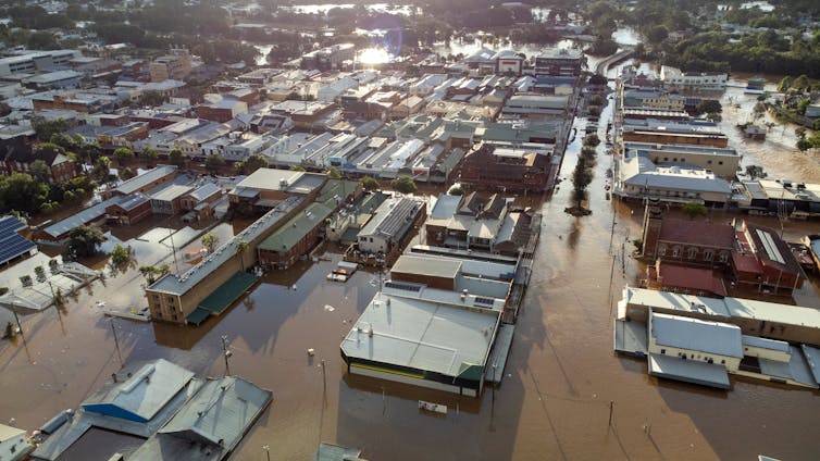
This is the exact weather set up that caused the devastating floods in Lismore and other places in February to March 2022.
In fact, a recent study showed 72% of all heavy rainfall events over the eastern seaboard are caused by this same weather set up.
That said, we are unlikely to see the same devastating impacts we did in 2022.
The stalled systems causing the current wild weather are forecast to move away after two days. By contrast, the set up that caused the torrential rain in 2022 persisted for three and a half days. It may not sound like a big difference but to atmospheric scientists, it is.
The atmospheric river associated with the current event is also weaker, so there is less moisture in the air to turn into rainfall.

Cloudcatcher Media/Shutterstock
How will climate change affect these weather events?
Recent research found an increase in the intensity of rain from short (less than an hour long) downpours over Sydney.
Another study has shown the atmospheric moisture over Sydney is projected to increase by the end of the century.
However, the representation of certain weather systems in climate models isn’t good enough yet.
Since we are missing this key part of the puzzle, it’s still uncertain how heavy rainfall over eastern Australia may change in the future.
Recent funding to research on this topic and developments in powerful, high definition models should improve our understanding of how these weather events may change in the future.
In the meantime, for those about to face the current deluge, heed warnings from the SES and the Bureau.
Never drive through flood waters and if the sky does turn black, put your headlights on.
Read more:
Here’s why climate change isn’t always to blame for extreme rainfall
![]()
Kimberley Reid receives funding from the Australian Research Council Centre of Excellence for Climate Extremes.
– ref. Why is Australia’s east coast copping all this rain right now? An atmospheric scientist explains – https://theconversation.com/why-is-australias-east-coast-copping-all-this-rain-right-now-an-atmospheric-scientist-explains-227158


