Source: The Conversation (Au and NZ) – By Steve Turton, Adjunct Professor of Environmental Geography, CQUniversity Australia
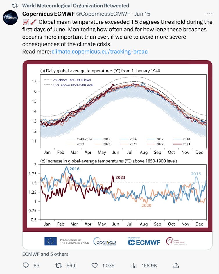
Recent spikes in ocean heat content and average global air temperature have left climate scientists across the world scrambling to find the cause. The global average air temperature, relative to 1850-1900, exceeded the 1.5℃ lower Paris Agreement threshold during part of March and the first days of June. This last happened in 2020, and before that during the powerful 2015-16 El Niño.
What makes these most recent temperature spikes so alarming is that they’ve occurred before a forecast El Niño event in the Pacific, rather than during one.
It is now clear that Earth’s climate system is way out of kilter and we should be very concerned.

Twitter @CopernicusECMWF
We already know El Niño events are associated with above-average global temperatures. Given the impending El Niño, we all need to take extra notice of what lies ahead for the next few years. This is especially so as this forecast warming event will follow the recent rare triple La Niña event that usually brings cooler average global temperatures, meaning the trajectory of this year’s uptick in average temperatures is likely to be even steeper.
Read more:
Is climate change outpacing our ability to predict extreme heatwaves?
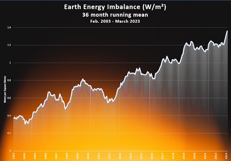
The Earth Energy Imbalance – the difference between the amount of energy arriving from the Sun and the amount returning to space – is now running at an all-time high. This is the most crucial measure of the prospects for continued global heating and human-driven climate change.
This metric will also be vital for monitoring our overall success in meeting the Paris Agreement’s targets, which call for humanity to hold average warming ideally to 1.5℃ above the pre-industrial average, or at least to as much under 2℃ as possible.
How much warmer are the oceans this year?
Since 1971, about 89 % of the excess heat in Earth’s climate system has been stored in the ocean (with 6 % on land, 1 % in the atmosphere, and about 4 % going towards melting ice on land and sea).
Because of this, any significant upward trend in average ocean heat is considered a harbinger for the acceleration of human-driven climate change more generally.
Scientists monitor the status of Earth’s energy imbalance by considering how much the average sea-surface temperature differs from the historical average, for a vast slice of the oceans covering everywhere between the Arctic Circle (60°N) and Antarctic Circle (60°S). These “sea surface temperature anomalies” are calculated each month, relative to the 1971-2000 baseline.
The global sea surface temperature anomaly on June 13 was about 4.5 standard deviations above the baseline global average. Put another way, this means the likelihood of current temperatures happening totally at random, if the climate this month was unchanged from the baseline period, are about 1 in 1.2 million.
This anomaly is so far above record levels it is judged almost statistically impossible to a have occurred in a climate without human-induced global heating.
The 36-month running average for the Earth Energy Imbalance is now at a record 1.36 Watts per square metre. This looks like a small value, but it corresponds to an average of 11 Hiroshimas of excess energy per second accumulating in Earth’s climate system over the past three years.

Professor Eliot Jacobson
Why is this happening now?
A range of natural and human climate drivers are behind this record global energy imbalance. These include rapidly declining sea ice in Antarctica and unusually warm temperatures in many parts of the world.
The early arrival of El Niño may also be playing a lesser role, as the warming in the central and eastern equatorial Pacific is not expected to peak until next year.
The submarine volcano Hunga Tonga-Hunga Ha’apai erupted in January 2022 and ejected record-breaking amounts of water vapour into the stratosphere. Water vapour acts as a potent greenhouse gas, and this may be contributing to the currently observed warming.
Other possible agents of warming include new regulations around sulfur aerosol emissions from shipping, and even a recent lack of Saharan dust. Both these forms of atmospheric aerosols have a cooling effect, as they reflect a small percentage of sunlight back to space.
Warm ocean anomalies are not restricted to the Pacific. The North Atlantic is incredibly warm at present. In fact, the entire North Atlantic has broken ocean temperature records for any time of year.
This pool of warm water has been linked to changes in the jet stream, creating a heat dome over eastern Canada and providing a catalyst for record-breaking wildfires.
If a strong El Niño develops later this year and continues in 2024-25, it will bring a very high risk of extreme climate-driven events around the world.
There is also a very high chance the warmest year on record will occur over the next five years.
Eastern Australia is an El Niño “hotspot”. This means an increased risk for drought, bushfires, heatwaves, crop failures and mass coral bleaching events on the Great Barrier Reef.
Greenhouse gases from human sources continue to rise and accumulate in the atmosphere. Rising emissions will fuel global heating, resulting in shifting climate baselines – what is often termed the “new normal” brought about by climate change.
Climate models predict with high certainty that as these climate baselines shift, so will the increased risk of extreme weather events. Effects of natural climate drivers, such as El Niño patterns in the Pacific, are likely to be amplified as the background climate warms.
Read more:
How much do marine heatwaves cost? The economic losses amount to billions and billions of dollars
Scientists will watch the current spike in global ocean and atmospheric temperatures very closely as the forecast El Niño strengthens later this year. What is less well understood is how other climate drivers may interact with the warming effects of El Niño.
Notably, how will the lingering atmospheric water vapour from the Hunga Tonga-Hunga Ha’apai eruption amplify any El Niño warming? All we can do is prepare for more record-breaking weather.
![]()
Steve Turton has previously received funding from the Australian Government. Steve is the vice chair of the Australian Citizen Science Association.
– ref. Global average sea and air temperatures are spiking in 2023, before El Niño has fully arrived. We should be very concerned – https://theconversation.com/global-average-sea-and-air-temperatures-are-spiking-in-2023-before-el-nino-has-fully-arrived-we-should-be-very-concerned-207731


