Source: The Conversation (Au and NZ) – By Brett Carter, Associate Professor, RMIT University
With technology increasingly embedded in our everyday lives, it is becoming more important to understand space weather and its impacts on tech.
When one hears “space weather”, one typically thinks of huge explosions on the Sun – coronal mass ejections hurled towards Earth, creating beautiful displays of aurora.
However, not all space weather starts at the Sun.
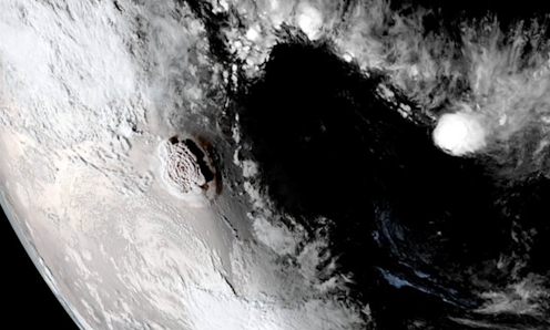
NASA Earth Observatory image by Joshua Stevens using GOES imagery courtesy of NOAA and NESDIS
The volcanic eruption in Tonga in January 2022 was so large, it created waves in the upper atmosphere that constituted their own form of space weather.
It was one of the largest explosions in modern history and impacted GPS across Australia and Southeast Asia. As we describe in our new study in the journal Space Weather, the eruption caused a super “plasma bubble” over northern Australia that lasted for hours.
A truly global positioning system
While most people have a GPS (global positioning system) receiver on their devices (such as a satnavs and smartphones), not many know how GPS actually works.
In essence, our devices listen to radio signals transmitted by satellites orbiting Earth. Using those signals, they calculate their location relative to the satellites, allowing us to orient ourselves and find that nearby pub or coffee shop.
The radio signals received by our devices are affected by Earth’s atmosphere (particularly the layer called the ionosphere), which degrades location accuracy. Common devices are only accurate to within tens of metres.
American Geophysical Union
However, new and improving precise satellite positioning systems, used within the mining, agriculture and construction industries, can be accurate to within ten centimetres. The only catch is these systems need time to lock onto their location, and this can take thirty minutes or more.
This precise satellite positioning works by accurately modelling the errors caused by Earth’s ionosphere. But whenever the ionosphere becomes disturbed, it becomes complicated and difficult to model.
For instance, when a geomagnetic storm (a disturbance in the solar wind that impacts Earth’s magnetic field) takes place, the ionosphere becomes turbulent and radio waves travelling through it get scattered – like visible light that becomes bent and scattered when looking down into a lake in choppy conditions.
Read more:
The Tonga volcanic eruption has revealed the vulnerabilities in our global telecommunication system
A volcanic disruption
Recent studies have shown the Hunga Tonga-Hunga Ha’apai volcano eruption caused choppy conditions in the ionosphere that lasted a few days. The size of the waves it generated in the ionosphere were similar in size to those created by geomagnetic storms.
While these waves influenced GPS data around the world for days after the eruption, their impact on positioning was rather limited in comparison to another type of disturbance in the ionosphere – a “super plasma bubble” that formed in the wake of the eruption.
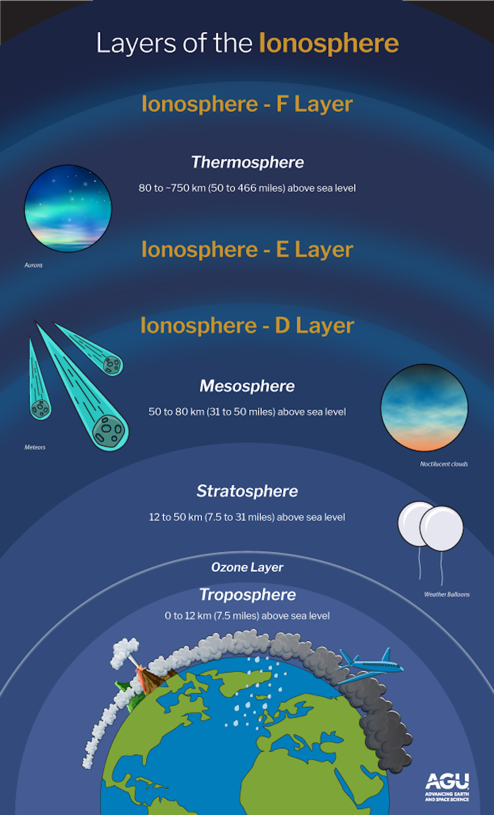
The ionosphere is a layer of Earth’s atmosphere at altitudes of approximately 80–800km. It comprises gas with lots of electrically charged particles, which makes it a “plasma”.
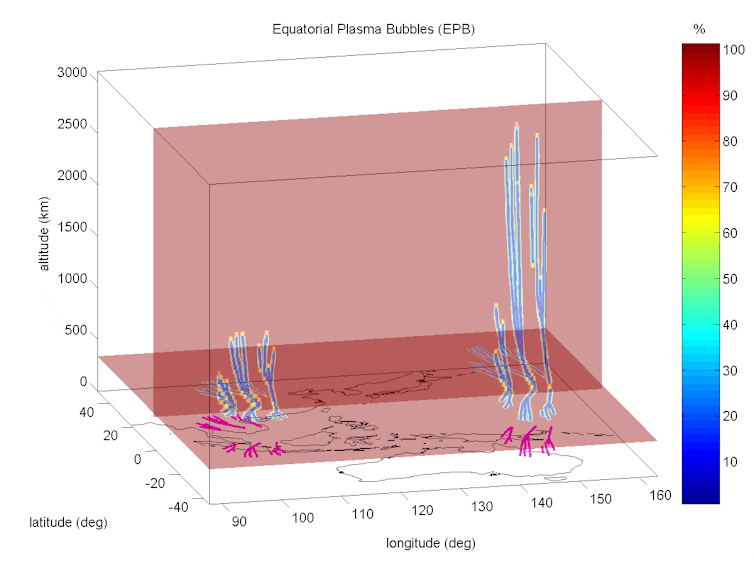
In turn, equatorial plasma bubbles are plasma disturbances in the ionosphere that naturally occur at nighttime above low-latitude regions.
Such plasma bubbles occur regularly. They form due to a phenomenon called the “generalised Rayleigh-Taylor instability”. It is similar to what happens when a heavy fluid sits on top of a less heavy fluid, and blobs of this lighter fluid rise up into the heavy fluid in the form of “bubbles” (see video below).
When it comes to disturbances in the ionosphere however, the plasma is also controlled by magnetic and electric fields.
As they rise, plasma bubbles form strangely shaped structures that resemble cacti or inverted tree roots. Due to Earth’s magnetic field, these structures fan out as the bubble grows above the equator.
The result is that higher altitude bubbles reach higher latitudes as well. Typically, plasma bubbles reach a few hundred kilometres above the equator, reaching latitudes between 15 and 20 degrees to the north and south.
Rezy Pradipta, Author provided
A rare bubble above Australia
Scientists detected a super plasma bubble above Southeast Asia shortly after the Tonga eruption. It’s estimated to be similar in size to previously reported rare super bubbles.
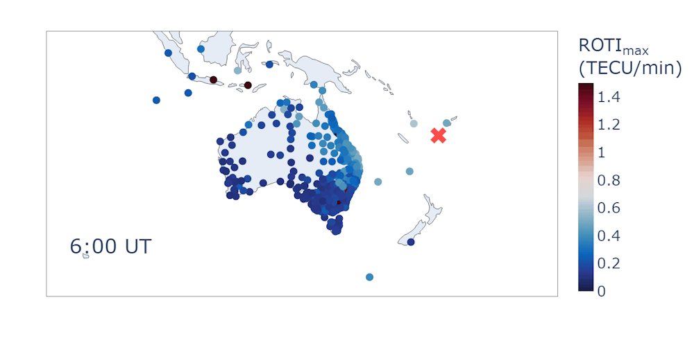
Earth’s magnetic field carried this disturbance south, where it lingered for a few hours above Townsville in northeastern Australia.
To date, this is the farthest south any plasma bubble has been observed over Australia. While very rare, such super bubbles are known to have taken place over northern Australia, but they haven’t been directly observed before this event.
A roll-out of GPS stations across northern Australia has only recently made this type of observation possible.
Brett Carter, Author provided
It is understood waves from the volcano eruption disturbed the winds in the upper atmosphere, altering the flow of plasma in the ionosphere and giving rise to the super plasma bubble.
Our study has found the bubble caused significant delays in the use of precise GPS across northern Australia and Southeast Asia. In some cases, getting a lock on the GPS location took over five hours longer due to the plasma bubble.
While we understand a lot about the ionosphere, our ability to predict its disturbances is still limited. Having more GPS stations is not only beneficial for improving positioning and navigation, it also fills gaps in monitoring the ionosphere.
The Tonga eruption was far from a typical “space weather” event caused by the Sun. But its impact on the upper atmosphere and GPS highlights the importance of understanding how the environment impacts the technologies we rely on.
![]()
Brett Carter is an Editor of the American Geophysical Union journal Space Weather. He receives funding from the Australian Research Council, SmartSat CRC and FrontierSI. He is also a member of the Australian Institute of Physics and the American Geophysical Union.
Rezy Pradipta receives funding from the Federal Aviation Administration (FAA), National Aeronautics and Space Administration (NASA), and United States Air Force Office of Scientific Research (AFOSR). He is affiliated with the American Geophysical Union (AGU).
Suelynn Choy receives funding from the CRC for Spatial Information, FrontierSI, Australian Research Council, SmartSat CRC and industry funding.
– ref. The Tonga volcano eruption caused a ‘super bubble’ in Earth’s ionosphere, disrupting satellite navigation – https://theconversation.com/the-tonga-volcano-eruption-caused-a-super-bubble-in-earths-ionosphere-disrupting-satellite-navigation-204546