Source: The Conversation (Au and NZ) – By Marco Amati, Associate Professor of International Planning, Centre for Urban Research, RMIT University
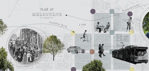
For 185 years, Melbourne’s Hoddle Grid – the ordered layout of CBD streets and blocks designed in 1837 – has dictated the flow of people and vehicles in the city centre. But how well does the grid serve 21st-century needs?
Melbourne faces three interconnected challenges that conflict with a business-as-usual, car-based grid. These are: how to end the dominance of cars; how to respond to the reality of the city centre as a residential area; and how to “reignite” post-pandemic activity in the CBD.
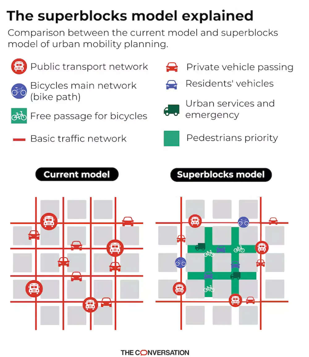
Superblocks are an approach, pioneered in Barcelona, to making urban areas more liveable and people-friendly.
A superblock covers an area of multiple city blocks – typically nine in a 3×3 format – that excludes through traffic. In this space, cyclists, walkers and residents have priority, though cars still have low-speed access to all buildings within the area. Superblocks transform formerly car-dominated streets into public spaces that can be used for a range of activities.
We have developed a step-by-step approach to introducing superblocks to Melbourne.
CC BY
Read more:
Superblocks are transforming Barcelona. They might work in Australian cities too
Colonialism lives on rent-free in our cities
The Hoddle Grid was used an instrument of power for expropriating land from peoples of the Eastern Kulin nation. It asserted formal control over lands that John Batman had acquired illegally.
The array of regular blocks would have helped with selling land to distant speculators by signalling equality among bidders, military control and efficient circulation of people and air.
For much of the 20th century, the grid has been open to vehicle through traffic. More recent developments have given nods to pedestrians, laneways and liveability.
Over 60% of street space in the grid is still given over to cars, although these account for less than 10% of all trips within the grid. As a result, it is still a significant site of injury, involving both road crashes and colonial dispossession.
While the grid has remained conceptually stuck in the late 19th and early 20th centuries, the central business district, despite its name, has become a residential area. Promoted by the Postcode 3000 project in the 1990s, there was a shift from a “doughnut city” – populated suburbs around a hollow centre – to a cafe society.
The city centre went from 750 registered residential units in the early 1980s to more than 96,000 today. This spurred a rise in the number of bars, cafes and restaurants.
To reshape the city centre in ways that better meet the needs of Melburnians now and in the future, the grid must be redesigned. It is time, in the words of Canadian scholar Vanessa de Oliveira Andreotti, to “wake up, smarten up, step up, own up, clean up, grow up, and show up”.
Read more:
Density, sprawl, growth: how Australian cities have changed in the last 30 years
How can superblocks improve the grid for people?
But how can superblocks be applied in car-dominated Melbourne? A staged and bespoke approach to gathering information and planning routes is needed. We suggest the following steps.
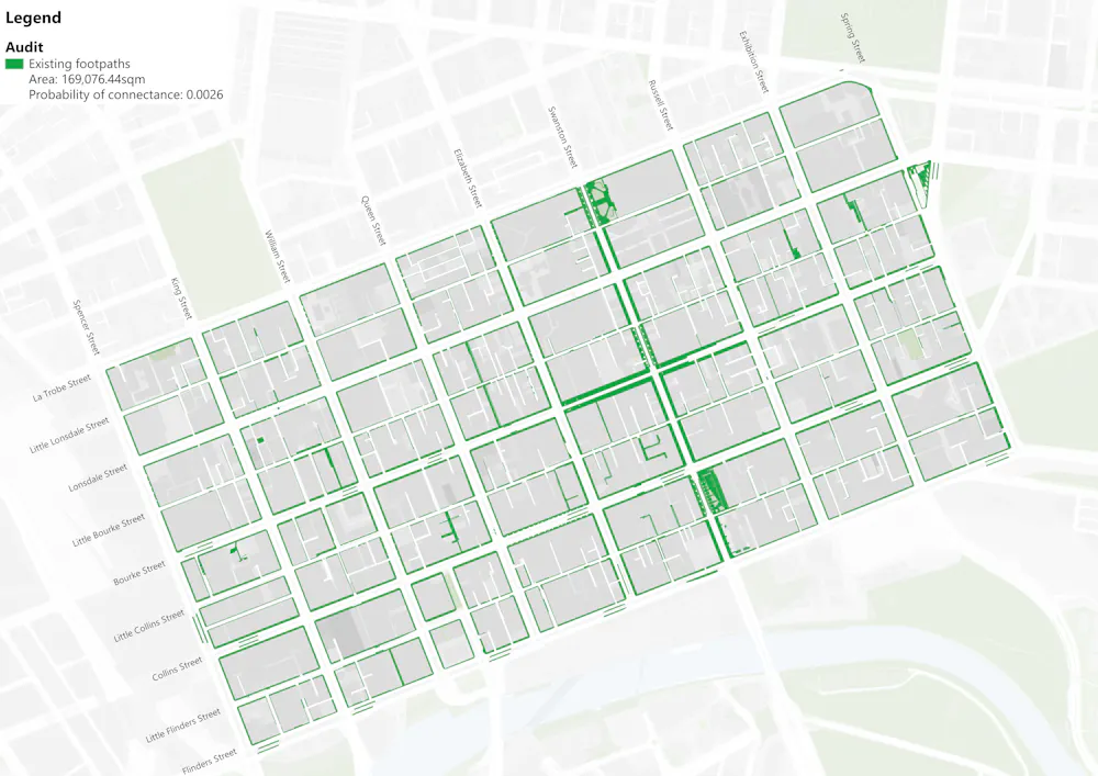
1. Audit the grid
Hoddle’s innovation was to have a mixture of little and main streets running parallel to one another. As a result, the sizes of junctions vary.
As well as assessing the locations of junctions and what they are like, in Melbourne we must also consider tram routes.
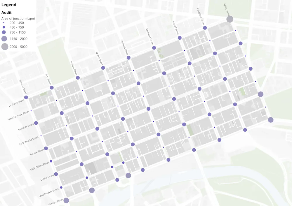
Map: Alexia Yacoubian and Mónica Suárez
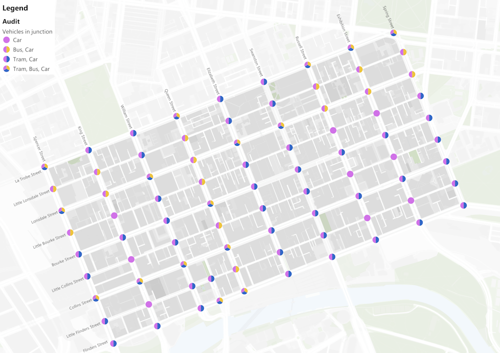
Map: Alexia Yacoubian and Mónica Suárez
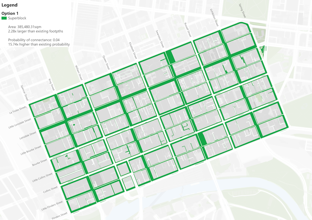
2. Work out what configurations are needed and where
The rectangular form, mix of large and little streets, tram lines and existing pedestrian areas all suggest departures from the “classic” 3×3 superblock that looks like a hashtag. We’re looking at including some 2×3 superblocks. All these forms should be considered to increase and improve space for pedestrians.
We propose four different options. In the following maps the green dots are junctions that have been made highly accessible for pedestrians. The more green dots, the better.
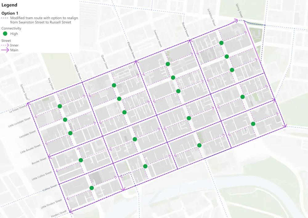
Map: Alexia Yacoubian and Mónicá Suarez
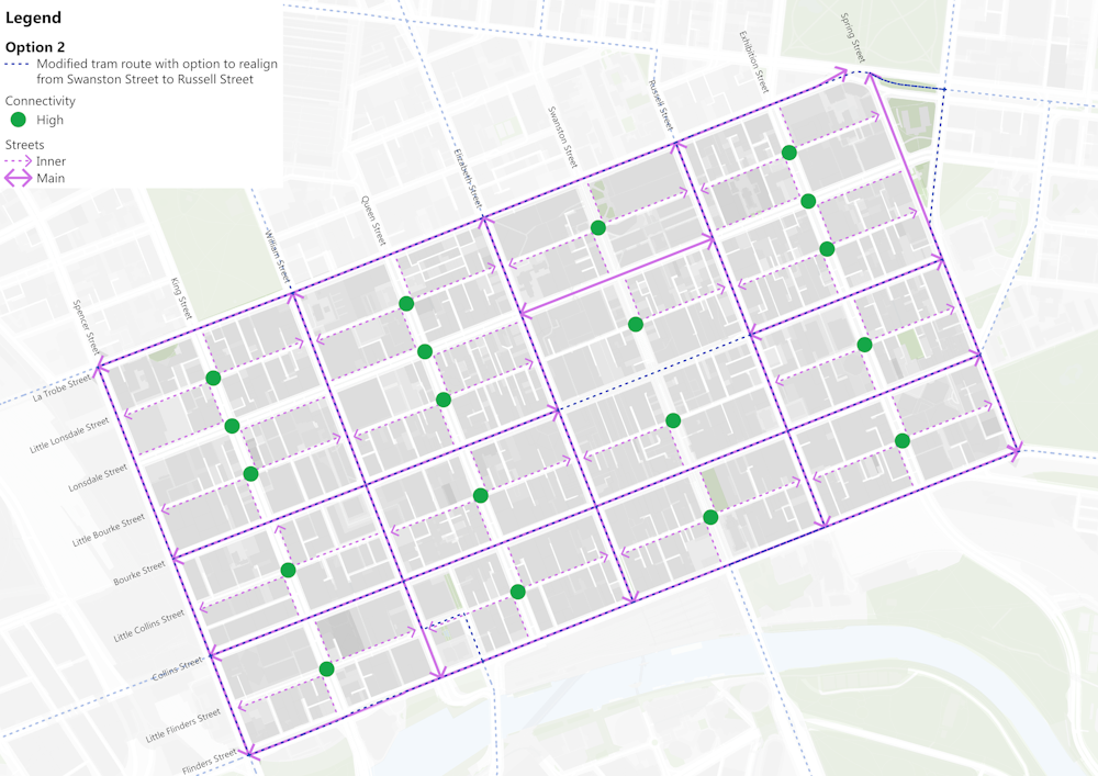
Map: Alexia Yacoubian and Mónicá Suarez
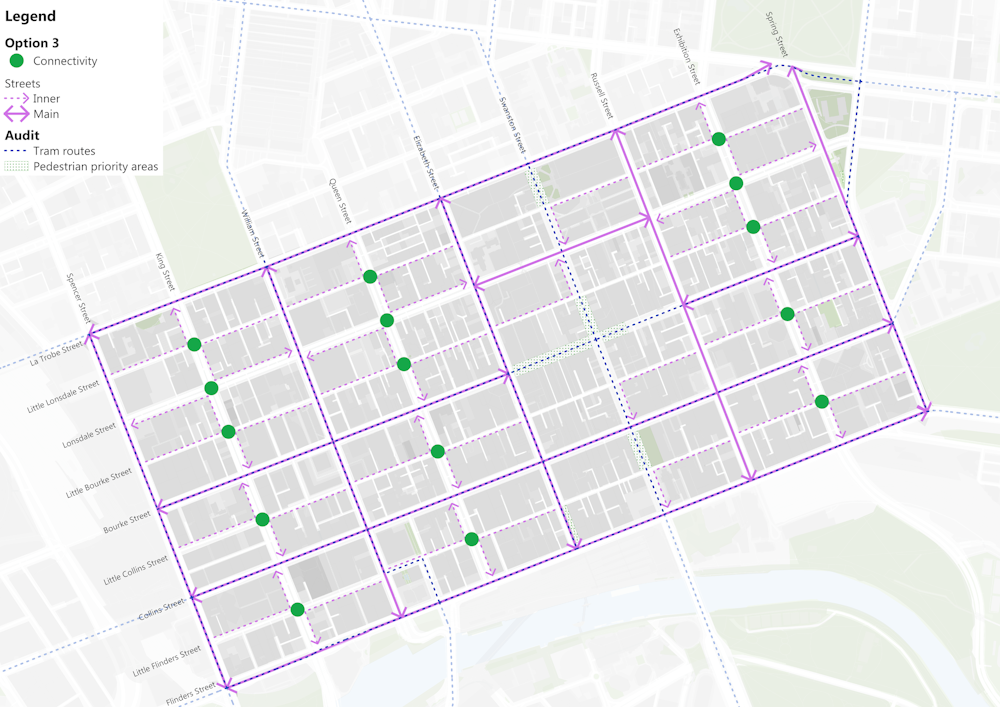
Map: Alexia Yacoubian and Mónicá Suarez
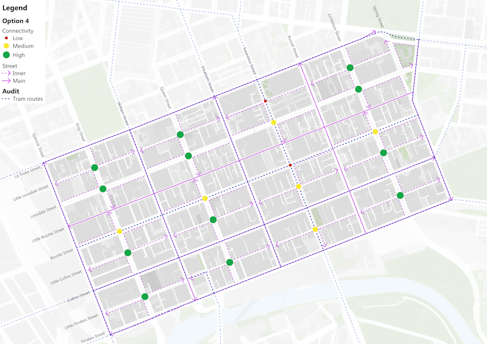
Map: Alexia Yacoubian and Mónicá Suarez
3. Assess the success of different options
Option 1 above increases the area of footpaths from around 169,000 square metres to 385,480 square metres – an increase of around 11 MCGs.
Map: Alexia Yacoubian and Mónica Suárez using data from City of Melbourne
Map: Alexia Yacoubian and Mónicá Suarez
Placing open spaces in junctions radically changes the pedestrian experience. Using a method from ecology, we can calculate a pedestrian connectivity index – the probability that a pedestrian can get from one point on a footpath to another in the grid without crossing a road. For the current grid, the probability is 0.2%. For the superblock model, it’s 4% – a 20-fold increase.
Even though pedestrians have more access, unlike a pedestrianisation plan, vehicle access to the buildings remains largely the same.
4. Decide how to use all this new open space
Once the questions shift from a matter of “if” to “how”, other questions come into play. What to do about car parking? We know off-street garages within 200 metres of on-street car parks could accommodate half of this parking.
How can these new spaces in junctions be used? The renderings below (by Mónica Suárez and Alexia Yacoubian using Google Street View images) provide some ideas. The first shows a “green dot” space where a car-only junction has been converted to pedestrian space. The second shows a “yellow dot” junction shared by trams and pedestrians.
Before and after: corner of Exhibition and Little Lonsdale streets
Before and after: corner of Swanston and Lonsdale streets
These are pilot ideas – e.g. the discussion should continue to how the grid interacts with surrounding streets and with Birrarung. But it could also act as a template for other cities in Australia that are similarly modern, colonial and grid-based.
5. It’s a marathon not a sprint
For more than 30 years, cities around the world from Curitiba to Barcelona have in effect been saying: thank you, dear car, for all you have given us in the 20th century, but now it is time to move on.
In practice, this needs to be a gentle and caring process with many steps, learning as we go. It is as de Oliveira Andreotti might argue, low-intensity activism and a marathon rather than a sprint.
Acknowledgments: The ideas in this article were developed as part of a workshop at RMIT. Participants included Zena Cumpston, Leanne Hodyl and representatives from City of Melbourne, Department of Transport, Yarra Trams, Infrastructure Victoria, RACV, RMIT, Melbourne and Monash Universities. Any errors remain the authors’.
![]()
Marco Amati receives funding from a variety of organisations including AURIN, ARC, Hort Innovation, State and Local Government. He is currently a co-convenor of this course: https://www.futurelearn.com/courses/green-corridors-for-clean-air
Chris De Gruyter receives funding from the Australian Research Council (ARC). He is a Fellow of the Australian Institute of Traffic Planning and Management (AITPM).
Salvador Rueda receives funding from multiple multilateral and national government sources. He is working pro bono on the Melbourne superblocks concept.
– ref. How superblocks can free up and improve CBD space for the people of Melbourne – a step-by-step guide – https://theconversation.com/how-superblocks-can-free-up-and-improve-cbd-space-for-the-people-of-melbourne-a-step-by-step-guide-193860