Source: The Conversation (Au and NZ) – By Michael-Shawn Fletcher, Associate Professor in Biogeography, The University of Melbourne
Shutterstock
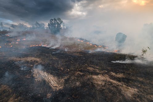
Southeast Australia’s bushfire crisis culminated in the devastating bushfire season of 2019 and 2020 that burnt nearly 25 million hectares of bush.
Our new research demonstrates how the scale of this disaster blew out due to legislation introduced in the 1970s, which was based on idea that nature should be left to grow freely without human intervention.
We investigated the bushfire history of one of the worst hit areas: Buchan on Gunaikurnai Country in Victoria. We found no bushfires burned there for almost a century until the mid 1970s, following the establishment of the Land Conservation Act of 1970 – legislation that sought to protect the Australian bush from humans.
This legislation banned farmers from mimicking Aboriginal burning practices by using frequent fires to promote grass for livestock. As a result, the amount of flammable trees and shrubs exploded in the region. It was only after this prohibition on burning that catastrophic bushfires became an issue in the Buchan area.
The prolonged neglect of southeast Australian forests under the guise of conservation means our forests now carry dangerous levels of fuels. This creates the conditions in which climate-driven bushfires become megafires, devastating Country and people’s lives.
Cultural burning as caring for Country
Aboriginal people make use of all kinds of vegetation, from closed forest to treeless grasslands, from freshwater to sea Country. Each mob care for Country according to their own laws and philosophies. The principal (but not only) tool for caring for Country is fire – a process now referred to as cultural burning.
The Victorian Traditional Owner Cultural Fire Strategy eloquently captures what cultural burning is:
Cultural Burning is Right Fire, Right Time, Right Way and for the right (cultural) reasons according to Lore. There are different kinds of cultural fire practices guided by Lore applicable across Victoria’s Countries.
Prior to British invasion, caring for Country led to diverse territories comprised of all the things people needed for themselves or for trade.
In contrast to hazard reduction burning, cultural burning is not a homogeneous application of fire designed simply to keep fuel loads low. It is a sophisticated and diverse system dictated by an intimate and reciprocal relationship with Country.
Philip Schubert/Shutterstock
Aboriginal care for Country promotes a safe, productive and predicable world. It is regulated by strict spiritual, cultural and pragmatic protocols.
It is intimate and small-scale. It is year-round. It is long term. It has both immediate and cumulative impacts on Country. This includes increased biodiversity, fewer catastrophic bushfires, productive lands and waters, and a safe home for people and other occupants of Country.
Settler farmers and open Country
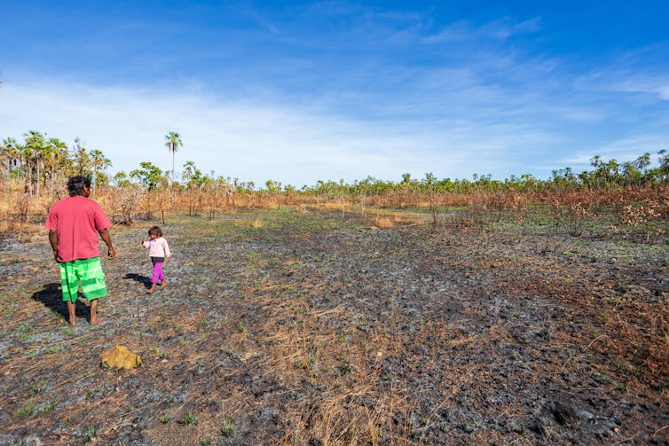
Settler farmers in southeast Australia capitalised on the systematic, fine-grained and diverse set of ways Aboriginal people applied fire to Country. Indeed, most agricultural areas in the southeast today occur on Country that was already open and grassy because of the application of fire over millennia.
This open Country was deemed desirable land. Much of it was further cleared for agriculture, while “less desirable” land was essentially neglected or viewed as a sources of timber.
These neglected areas have become much more woody and, as a result, much more fire prone.
Read more:
This rainforest was once a grassland savanna maintained by Aboriginal people – until colonisation
Until the 1970s, many settler farmers observed and mimicked the practice of cultural burning. They particularly desired the benefits of increased green shoots following low-intensity burning of grasses to feed their livestock, and the safety from uncontrolled bushfires such burning provided in this perilously flammable environment.
For a 2008 Victorian government inquest into the impact of public land management practices on bushfires, Buchan locals commented on the causes of bushfire in the region. A statement from a Buchan farmer reads:
After Europeans arrived the settlers followed the Aboriginal ways and the country was all open, rolling grassland. My father said it was paradise on earth. Orbost right through Gelantipy, Wulgulmerang, Omeo and all that country was rolling grassland, and the settlers came there because it was great for their cattle.
After the limitations on [Aboriginal] people, the settlers followed their ways and the country retained its grassland quality. […] Then the regulations began to be more and more restrictive. Public land management and the responsibility of the Minister, have been evaded, over a long time.
How the landscape changed
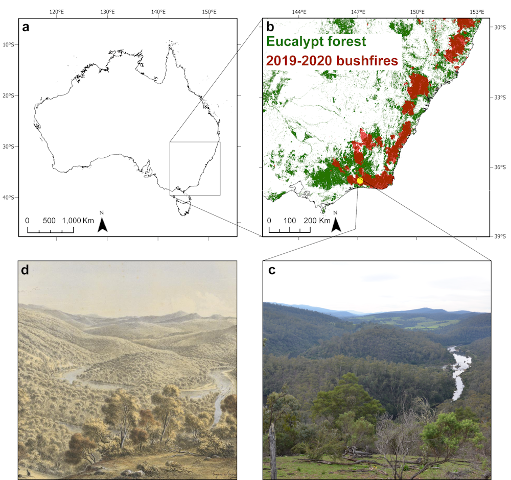
For our study, we extracted a long sample of sediment from the Tooculerdoyung Lagoon on the banks of the Snowy River, near where it joins the Buchan River. Studying the pollen and charcoal contained in this sample reveals how vegetation, fire and erosion changed in this region over the past 120 years.
Tooculerdoyung is a local Gunaikurnai word that translates to “a point of river”.
The site is currently surrounded by eucalypt-forest. It is depicted in a well-known lithograph by realist painter Eugene von Guérard in 1867, in which the landscape surrounding the site is portrayed as an open forest.
Laming et al. 2022, Author provided
Our data confirms von Guérard’s depiction. From the early 1900s (shortly after the town of Buchan was established in 1873) until the 1970s, the area was indeed an open landscape, dominated by grass and herbs. In this time, it experienced a consistent, low-intensity fire regime (fire pattern).
After 1970, the fire regime becomes more variable, with a shift to less frequent and higher impact burning. This is accompanied by a drastic increase in the amount of flammable trees such as eucalypts and shrubs. For the first time in the region, we see the onset of post-fire soil erosion.

Michael-Shawn Fletcher, Author provided
Buchan locals lay the blame for this fire regime shift on the banning of settler mimicry burning. In a submission to the 2008 inquiry on public land management and bushfires, local Buchan residents wrote:
It was 35 years ago when the use of the burnt areas for cattle grazing was stopped […] when the Land Conservation Council first started.
[…] That is when the demise of all this started happening. The older ones who are still around will still tell you that one day they will burn us out, because there is no management in the bush anymore as far as fire suppression goes, and, really, it is coming true.
We implore land management agencies to rethink the way Country is perceived and cared for. Country needs people and the neglect of our forests is destroying them.
Aboriginal people hold the knowledge, connection and desire to return health to their Country and they must be supported to do so.
![]()
Michael-Shawn Fletcher receives funding from the Australian Research Council
Michela Mariani receives funding from the Australian Research Council. She is affiliated with the Centre of Excellence for Australian Biodiversity and Heritage (CABAH) at the Australian National University.
Russell Mullett is affiliated with the GunaiKurnai Land & Waters Aboriginal Corporation, which receive grants from government – Ranger Program/Registered Aboriginal Party to support employment and operational funding. We are a non-profit Organisation.
Simon Connor receives funding from the Australian Research Council through its Indigenous Discovery programme. He is also a member of the Victorian National Parks Association.
Anthony Romano does not work for, consult, own shares in or receive funding from any company or organisation that would benefit from this article, and has disclosed no relevant affiliations beyond their academic appointment.
– ref. How 1970s conservation laws turned this ‘paradise on Earth’ into a tinderbox – https://theconversation.com/how-1970s-conservation-laws-turned-this-paradise-on-earth-into-a-tinderbox-192401