Source: The Conversation (Au and NZ) – By Rohan Fisher, Information Technology for Development Researcher, Charles Darwin University
Shutterstock
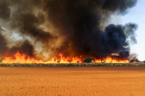
While southern Australia experienced a wet winter and a soggy spring, northern Australia has seen the opposite. Extreme fire weather in October and November led to bushfires across 120,000 square kilometres of southern savanna regions.
Significant fires continue to burn in the Kimberley, the Top End, Cape York and the northern deserts. And while recent rain across the central deserts has reduced the current fire risk, it will significantly increase fuel loads which creates the potential for large wildfires in summer.
We are professional fire watchers. The lead author of this article, Rohan Fisher, maps and monitors fires across the tropical savannas and rangelands that comprise 70% of the Australian continent. The scale of burning we’re now seeing astounds us – almost as much as the lack of interest they generate.
This continent’s fire ecology is poorly understood by most Australians, despite recent significant bushfire events close to big cities. But as we enter the Pyrocene age under worsening climate change, good fire knowledge is vitally important.
Read more:
Australia, you have unfinished business. It’s time to let our ‘fire people’ care for this land
Philip Schubert/Shutterstock
In the desert, fire and water are linked
Fires in arid Australia are extensive, largely unmanaged, often destructive and significantly under-reported. Improving their management involvement is crucial to both Traditional Owners and the ecological health of our continent.
To improve pyro-literacy, we developed a mobile app to map fires across most of Australia in real-time.
This year, Western Australia and the Northern Territory experienced serious heatwaves late in the year and a late start to the wet season. This provided the perfect bushfire conditions.
In contrast, central Australia has experienced rare flooding rains, including at Alice Springs which recorded the wettest November on record. This creates dangerous fuel loads heading into summer.
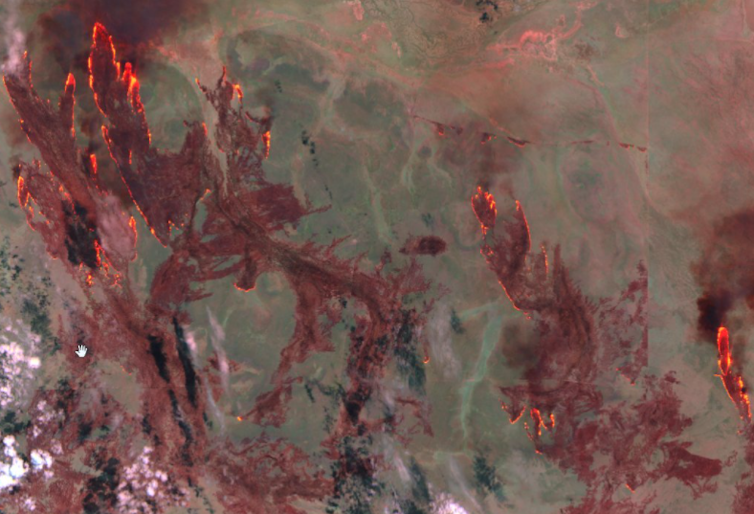
In the desert, water and fire is coupled in both space and time. Fire burns where water flows, because that’s where fuel – in the form of vegetation – is heaviest.
The below satellite image from the Pilbara illustrates this point. It shows the path of an arid-zone fire flowing like water along dry creeks and drainage lines.
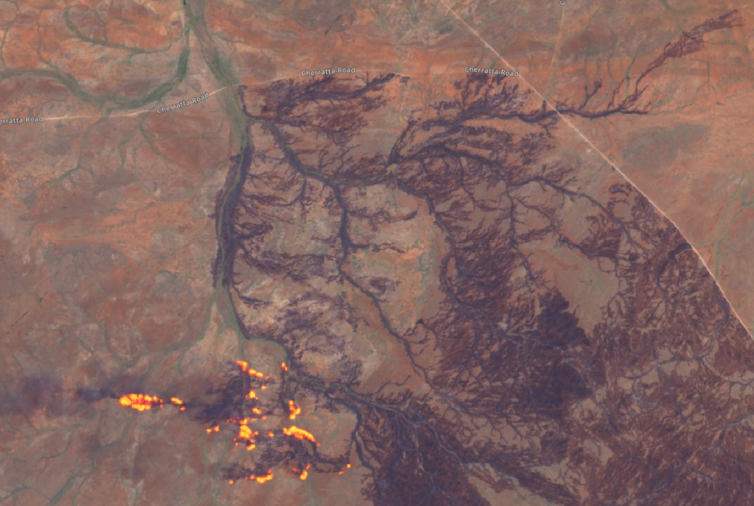
Where country is not managed for fire, it can lead to catastrophic outcomes.
The incidence of previous fire also influences fire spread. Without the regular application of fire, large tracts of desert can accumulate heavy fuel loads, primed for ignition.
Over a few months in 2011, our data show more than 400,000 square kilometres in central Australia burned – almost twice the size of Victoria. It was one of the largest single fire events in recent Australian history and coincided with the wet La Nina period in 2010-12.
Watching from satellites in space, we mapped the spread of the fires in near-real time, as this video shows:
Fire management through time
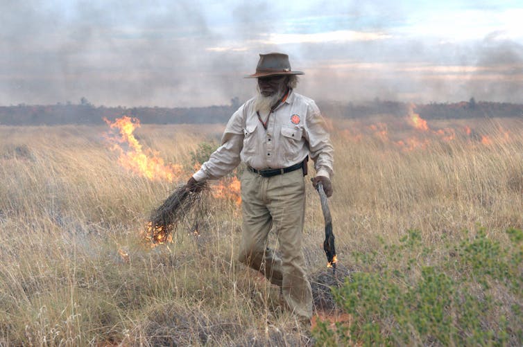
For many thousands of years, Australia’s Indigenous people have skilfully burned landscapes to manage country. Most fires are relatively low-intensity or “cool” and do not burn large areas. This results in a fine-scale mosaic of different vegetation types and fuel ages, reducing the chance of large fires.
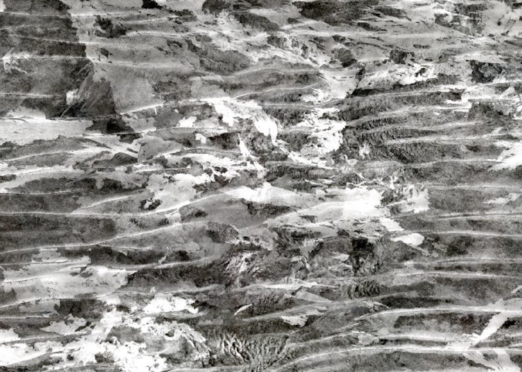
Researchers have looked back in time to provide insight into fire management as it once was. This was done using aerial photography taken in the 1940s and 1950s in preparation for missile testing at Woomera in South Australia.
The below aerial photo from 1953 reveals a complex mosaic of burn patterns and burn ages – a result of fine-scale land management by Traditional Owners.
But following the displacement of Indigenous people and the decline of traditional burning practices, fire regimes changed dramatically. The average fire size today is many orders of magnitude greater than those set under Aboriginal management.
The change has been implicated in the decline and extinction of some mammals and plant species. One massive and fast-moving October fire in the Tanami desert – home to endangered bilbies – burned nearly 7,000 square kilometres over a few days, our data show.
Read more:
Not all blackened landscapes are bad. We must learn to love the right kind
Back to desert burning
Like everywhere on this continent, fire in our vast deserts must be well-managed. Getting people back on desert country to reintroduce complex fire mosaics is difficult work but will have significant benefits for both nature and Indigenous people.
Challenges include building capacity amongst ranger groups and communities, overcoming legal and insurance hurdles and employing novel techniques to apply “cool” fires at a near-continental scale.
The role of Indigenous ranger groups is critical here. Organisations such as 10 Deserts – a partnership between Indigenous and conservation organisations – are supporting desert fire work.
Peter Murray is chair of the 10 Deserts project and a Ngurrara Traditional Owner from the Great Sandy Desert. On the importance of this work, he says:
Right now, we’re working on Indigenous “right way” cultural burning as a means of preventing wildfires. We’re developing dedicated male and female ranger teams to look after the land and develop tourism. And we’re encouraging traditional owners to return to the desert to share and exchange knowledge as well as collecting and storing that knowledge to pass onto younger generations.
Kanyirninpa Jukurrpa/Gareth Catt
Living in the Pyrocene
As climate change worsens, we’re now living in a global fire age dubbed the Pyrocene. This will bring challenges across the Australian continent.
Throughout remote Australia, increasing extreme fire weather will see more severe bushfires. Good fire management in these landscapes is urgently needed. In the northern tropical savannas, Indigenous-led fire management at the landscape scale is already producing some of the worlds best fire management outcomes.
The challenge is to introduce similar scales of fire management across our vast deserts. These regions are rich with nature and culture, and they deserve far more attention than they’ve received to date.
Read more:
5 big ideas: how Australia can tackle climate change while restoring nature, culture and communities
![]()
Rohan Fisher receives funding from the federal Department of Agriculture, Water and the Environment and the Department of Industry, Science, Energy and Resources.
Neil Burrows is affiliated with the Liberal party
– ref. We are professional fire watchers, and we’re astounded by the scale of fires in remote Australia right now – https://theconversation.com/we-are-professional-fire-watchers-and-were-astounded-by-the-scale-of-fires-in-remote-australia-right-now-172773